The marker points to the location of Tell Damiyah.
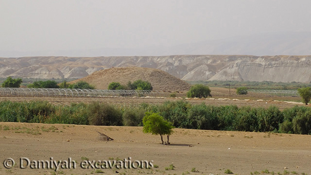 The steep-sloped mound of Tell Damiyah is located along the eastern bank of the Central Jordan Valley (see the image at the left; image courtesy of Lucas Petit; hover over to enlarge). The site covers 2.9 hectares and rises c.17m from the valley floor. The large upper mound contains the site, which has a commanding view across the valley to the site of Tell es-Sa'idiyeh (about 20km north). The site was surveyed in the 19th century and test trenches were sunk in 2004 and 2005. Full excavations began in 2012 as a joint operation co-directed by Lucas Petit (Rijksmuseum van Oudheden, Leiden, Netherlands) and Zeidan Kafafi (Yarmouk University, Irbid, Jordan).
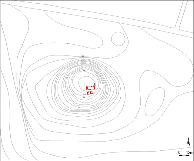 Tell Damiyah seems to have occupied more or less continuously from the Early Bronze Age through until the Ottoman Islamic period of the late 2nd millennium CE. The most significant settlement occurred during Iron Age II, between the 9th and 6th centuries BCE (see the topographic plan of the mound and vicinity at the left, with the Iron Age remains in red; plan courtesy of Lucas Petit; hover over to enlarge). So far, excavations have uncovered remains of two important Iron Age structures (what appears to be a domestic building and a religious structure), dozens of artifacts (including pottery, figurines, scarabs, loom weights, and animal bones), and a roadway leading up from the valley to the settlement. During the Persian and Hellenistic periods (c.550-200 BCE), the site was mainly comprised of storage pits and no permanent architecture. Later, during the Byzantine and Ottoman periods, the mound became a cemetery (over 30 graves were cleared in 2012 and 2013).
The primary goal of the fieldwork is to recover and reconstruct the settlement history of the site from the Late Bronze Age (around 1400 BCE) through the end of Iron Age II (around 500 BCE). It is hoped that the excavations will shed light on the lengthy survival of the settlement at the fringes of Assyrian and Egyptian territorial influence, through periodic droughts, earthquakes, and a site-wide fire around 700 BCE. Was this a site of a provincial governor, a waystation along the valley, or perhaps a local religious center and storage site for travellers?
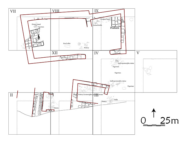 Stratum VII was the focus of the first investigations into the nature of the settlement during its height, around 700 BCE, Iron IIc. Architectural remains from this period include part of a domestic structure to the south of the central roadway and an incompletely preserved religious structure to the north (see the plan at the left; image courtesy of Lucas Petit; hover over to enlarge). Both buildings were built of mudbrick and both were destroyed by fire at the end of this period, along with other sites in the valley.
How could Learning Sites expertise help the fieldteam better understand their finds, the architectural contexts, and the nature of the site within the valley landscape?
 Learning Sites began by modeling the valley environment around the mound and then the mound itself. The 3D digital model was enhanced by stitching together photographs taken by the fieldteam from atop the mound looking all around the valley (see the rendering at the left showing a view northwest across the valley toward the mound; hover over to enlarge). Such renderings provided the excavators with an impression of how much of the settlement could have been seen by passersby.
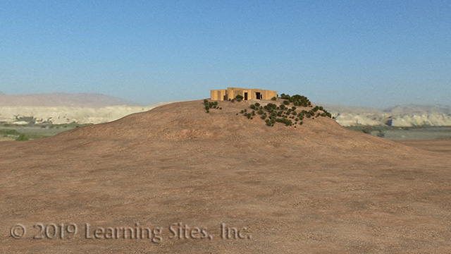
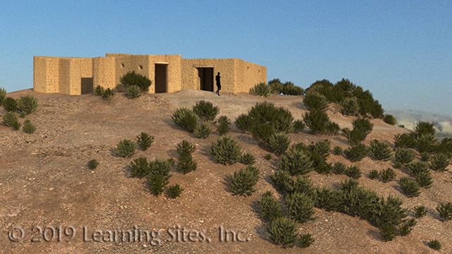 Two structures have been uncovered so far atop the mound, which Learning Sites is just beginning to digitally reconstruct so that the fieldteam can visualize the settlement, test theories about its development, and learn more about how the buildings were used (see the rendering at the left; hover over to enlarge). The building to the south of the roadway (on the left in the rendering) seems to have been a house based on the domestic artifacts found (e.g., grinding bowls, grind stones, loom weights, large storage vessels, and cooking pots) and the lack of associated cult objects.
The second structure found on the north side of the road (at the right in the rendering) seems to have been a religious building, based on the artifacts and built-in platforms (near which were found several, small painted figurines and bovine skulls). The roadway, which wound up from the valley along the eastern side of the mound between the structures, had a hard surface of packed pebbles and clay.
Paper Publications
Guérin, Victor
1869 Description géographique, historique et archéologique de la Palestine accompagnée de cartes détaillées. Paris.
Petit, Lucas
2013 "Recycling the Valley. Preliminary Report of the 2012 Excavations at Tall Damiyah," Annual of the Department of Antiquities of Jordan 57:239–46.
2009 "A Wheel-Made Anthropomorphic Statue from Iron Age Tell Damieh, Jordan Valley." Pp. 151–60 in Eva Kaptijn & Lucas P. Petit, eds., A Timeless Vale. Archaeological and Related Essays on the Jordan Valley in Honour of Gerrit van der Kooij on the Occasion of His Sixty-Fifth Birthday. Leiden: Leiden University Press.
Petit, Lucas & Zeidan Kefafi
2016 "Beyond the River Jordan: A Late Iron Age Sanctuary at Tell Damiyah," Near Eastern Archaeology 79.1:18-26.
Digital Resources