3D Modeling and Virtual Heritage: the case of ancient Nineveh

Paper delivered by Donald H. Sanders, PhD, at the Creating and Recreating Nineveh symposium held at the Rijksmuseum van Oudheden, Leiden, the Netherlands, on January 22, 2018, on the occasion of their exhibition on ancient Nineveh. Below is the text from the talk, minus the interactive virtual worlds that were shown during the presentation.

posted here September 17, 2019


 I. Introduction

18th c. renders of the ancient world
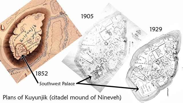
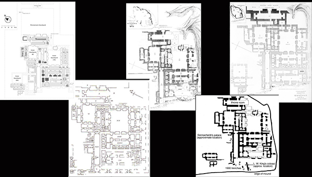
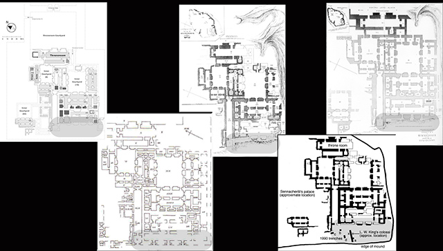
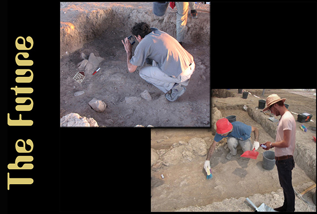
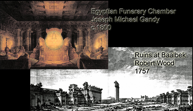
Understanding the distant past isn't easy; we weren't there! Archaeology (the study of the material culture of the past) emerged in the age of fine draftsmanship, meticulously refined renderings crafted slowly by hand, and equally elaborate prose (see sample 18th c. renderings at the left; hover over to enlarge). But that was centuries ago, and you don't see many people these days riding in horse-drawn carriages, writing books with quill pen, or finding their way by candlelight. So, why is the study of the past today, for the most part, still constrained by the 19th-c. conventions of hand-drawn plans, static photos, and long descriptive lists? I'm not saying that those things are bad; I'm saying that we've moved on.

sample plan and photo
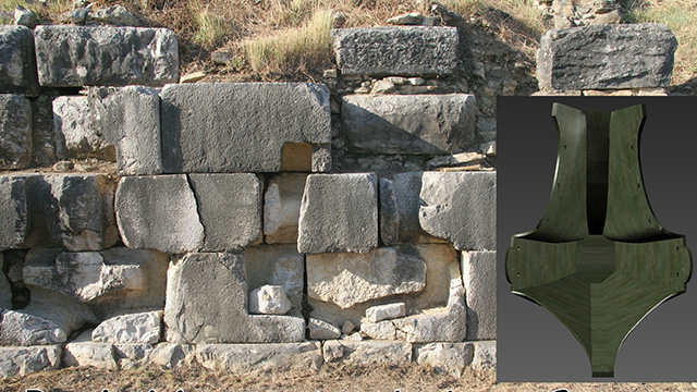
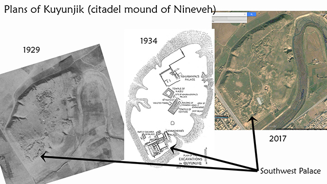
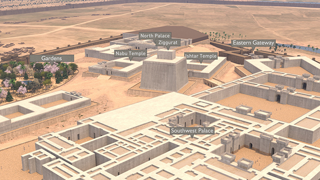
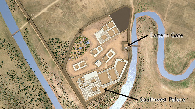
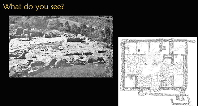
Further, classes teaching archaeology using slides often find that students have difficulty deciphering ancient sites from only plans and views (what do you see at the left? hover over to enlarge). Even archaeologists have trouble interpreting a scatter of rocks, let alone envisioning how ancient people lived and used these sites.

artist sketches of the same structure
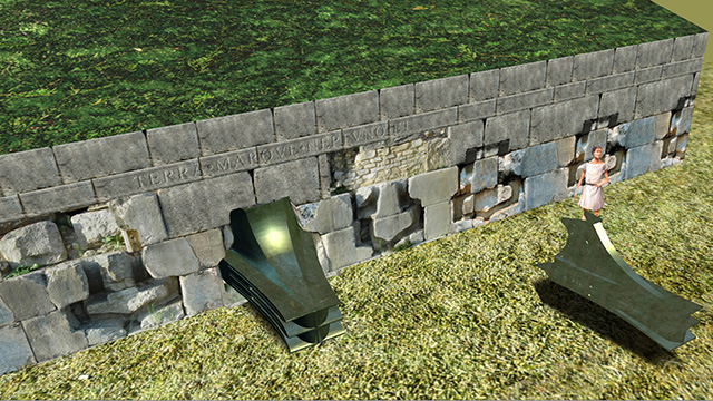
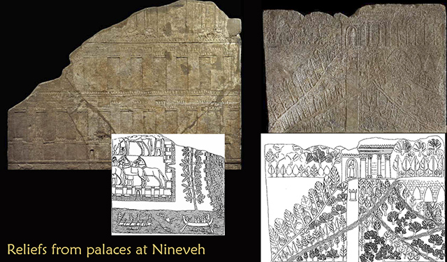
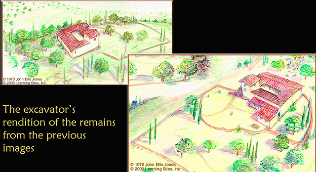
Artists' impressions offer some additional information, but there must be a better way to teach history, test hypotheses, and validate interpretations. It took a while for computers to catch up our visualization wishes (the excavator's own reconstruction sketches at the left; images courtesy of J. E. Jones; hover over to enlarge).

Learning Sites renderings of the same structure
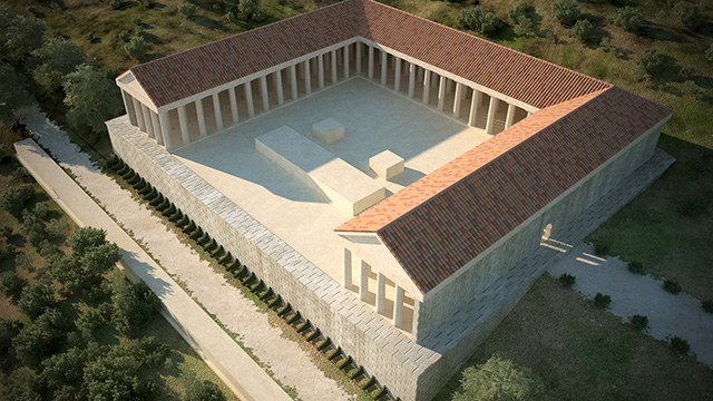
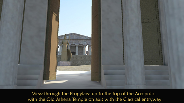
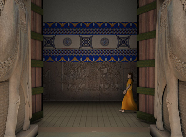
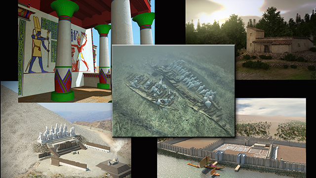
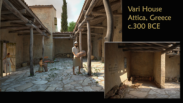
But now we can appreciate ancient places in ways that approximate the viewpoints of the original inhabitants, using virtual reality (sample renderings from the Learning Sites virtual reality model of the Vari House; hover over to enlarge; to take a real-time virtual tour of the Vari House, see the Learning Sites homepage).

example of an early digital reconstruction
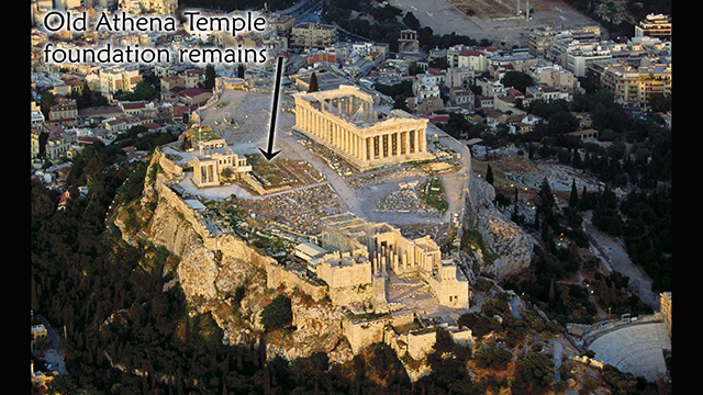
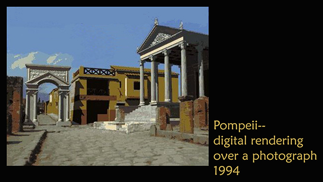
Already by the 1980s, computers were helping us visualize archaeological finds, mostly by way of low-resolution 3D models of small objects. As software improved, entire buildings and sites could be digitally reconstructed with the 2D output renderings enhanced using image-editing tools (see a example of an early digital reconstruction at the left; hover over to enlarge). A leap in capability occurred in the early 1990s when virtual reality left the lab and hit mainstreet -- but at a price. Viewing virtual worlds in the 1990s required million-dollar computer workstations and graphics cards the size of refrigerators.

VR headsets
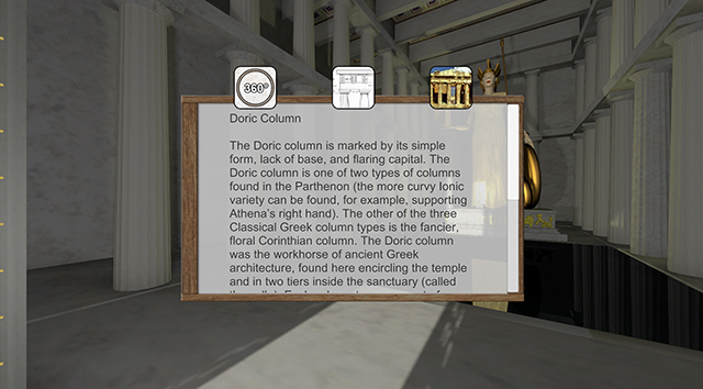
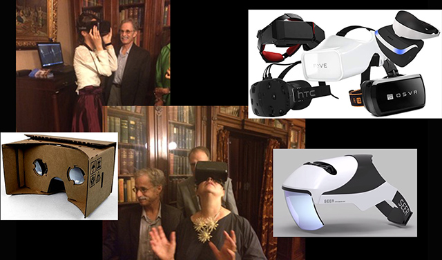
Today VR can be enjoyed on laptops, smartphones, and numerous low-cost headsets of increasing fidelity (such as with the gear pictured at the left; hover over to enlarge). Virtual reality is interactive, self-directed, real-time navigation through a computer-generated 3D space that displays a synthetic scene. When this technology was embraced by a few innovators in the early 1990s, digital archaeology spawned virtual heritage. Virtual heritage, then, is the use of virtual reality technologies for the visualization of the past. After all, since the past happened in 3D and in color, that's how it should be studied, taught, and published! And, interactive 3D computer models permit more innovative inquiries than are possible when using traditional 2D paper-based media.

montage of Learning Sites projects
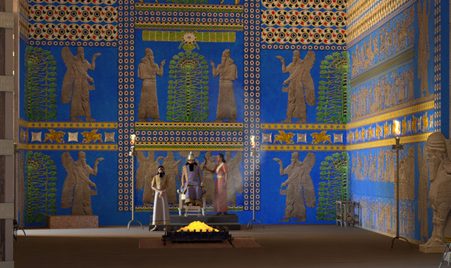
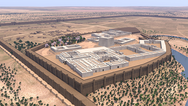
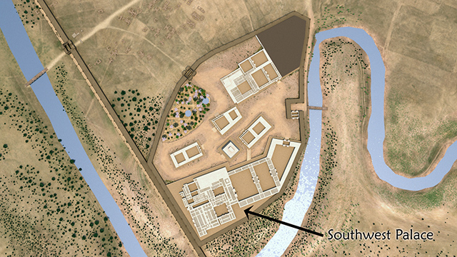
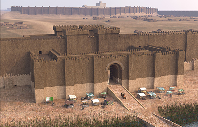
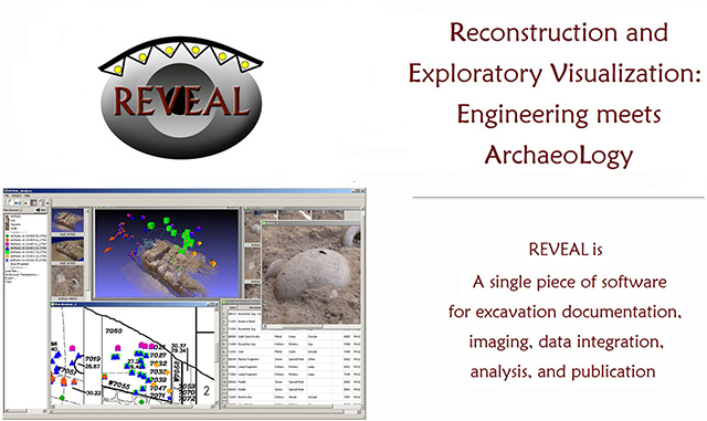
My company, Learning Sites, digitally reconstructs sites, buildings, artifacts, and events for archaeologists, museums, schools, publishers, antiquities services, and broadcast. We're the oldest company in the world dedicated to virtual reality-based archaeological education and research, working to bring history to life through vivid visualizations of the past re-created to the highest standards of scholarship. To complement today's other presentations, I'll discuss virtual heritage, some projects that we've modeled over the past 25 years, with a focus on our work at Nineveh, and conclude with a glimpse at a paradigm shift about to hit archaeological fieldwork.


 II. Examples of our Work

photo of the Athlit ramVirtual heritage, for example, allows us to study single objects in ways unthinkable with 2D media and difficult to do when the objects are far away. At the left is an image of the only surviving intact, ancient Roman, ramming prow, on display in Israel (hover over the image to enlarge).

prow of a Roman warshipThe massive weapon weighs several tons, is made of bronze, and was affixed to the front of a warship in order to ram into an enemy's vessel (see the mockup at the left; hover over to enlarge). To help scholars study the ram remotely and from all directions, we created a VR model from published photos, drawings, and measurements. Hold that thought.

excavated site of Actium, GreeceIn 33 BCE, Emperor Augustus built a monument at Actium, Greece, in thanksgiving for his naval victory over Mark Antony and Cleopatra (see the excavation photo at the left, provided courtesy of William Murray; hover over to enlarge).

long wall at ActkumAt the site, archaeologists found a wall with these funny-looking shapes cut into its entire length (see the image at the left, provided courtesy of William Murray; hover over to enlarge).

sockets and Athlit ram backRemember that virtual ram from a moment ago? When researchers using our model turned it all the way around they were surprised to see....a familiar shape -- the negative shape of the backs of rams (see the image at the left; photo courtesy of William Murray; hover over to enlarge). Each socket is unique in its size and shape, reflecting the dimensions of the actual rams at the point of contact with the wall.

testing the fit of a ram modelWe warped our 3D computer model of the surviving ram while keeping the proportions intact until it fit into a test socket. The process taught us about the specific problems that were faced and solved by the Augustan builders in fitting the rams into the sockets.

full site reconstructionWe will also be able, for the first time, to test the accuracy of (often conflicting) claims made by ancient writers regarding the size and composition of the warring fleets, since here we will have a good representative sample of the weapons and thus the size of the ships actually used in the battle. Thus, through virtual heritage we could use one far-away object to discover the true meaning of odd cuttings at a distant archaeological site. VR allowed researchers to ask questions and test theories about the archaeological data that couldn't have been attempted otherwise.

Acropolis, aerial viewAnother example: Our challenge here was to reconsider the Classical monuments on the Acropolis in Athens, not with an aura of wonder, but instead in terms of a solution to a set of problems. We focused our attention on the major problem facing both statesmen and planners of the 5th century: what to do about the ruins of the Old Athena Temple burned during the Persian sack of the city.

sample Acropolis reconstructionsThe traditional hypothesis is that the unsightly rubble was swept away to make space for the Parthenon, Erechtheum, and Propylaea. Our partnering archaeologist questioned that prevailing narrative. We sifted through ancient inscriptions, ancient writers site descriptions, 16th-19th c. travelers' illustrations, and 2 centuries of excavations and measurements. We learned quickly that, no matter how many times the remains had been surveyed, no two sets of dimensions or elevations matched, leaving the buildings floating in relation to each other. Old photos in Harvard's archives and interactive 3D modeling allowed us to definitively settle the locational relationships and to argue that the Old Athena Temple stood in ruins as a war memorial for 2000 years.

view through the PropylaeaWe demonstrated how the Classical buildings were built specifically to take the Old Athena Temple's ruins into account, that the ruins remained the focus of the Acropolis, and survived amidst the dense warren of Turkish houses that were summarily cleared away in the 1830s without consideration that Athens' holiest building still remained standing. Thus, a virtual heritage approach forced re-evaluation of orthodoxy and a needed correction in the interpretation of basic bits of evidence.

educational links from the Parthenon virtual worldThis project also enables us to explore the educational benefits of virtual heritage. Historians need to think of virtual worlds as more than just pretty pictures; they are instead new ways to see and study the past, ways that can't be done when relying on 2D media alone. For example, we can create research resources, teaching materials, and new types of publications, where all the data remain in context inside the virtual world (for example, our Parthenon virtual world has links from objects that explain and describe that feature, complete with images, text, and interactives; see the image at the left; hover over to enlarge).

Northwest Palace, Nimrud, viewsAnother of our projects is the virtual re-creation of the Northwest Palace, built by King Ashur-nasir-pal II in the 9th c. BCE at Nimrud (35km south of Nineveh; see the images at the left; hover over to enlarge). This was best preserved of all the ancient Assyrian palaces, until it was completely dynamited by ISIS/Da'esh in 2015. The site was originally excavated by Austen Henry Layard from 1845-1851 (during the time he was also investigating Nineveh).

New Battle Abbey reliefsVisitors to Nimrud during and after Layard's excavations and received permission, literally, to mine the site of what were deemed duplicate images, some of them among the finest examples of Assyrian art. We've documented the whereabouts of 321 sculptures from the palace in 75 museums and private collections around the world (see the examples at the left; photo courtesy of Julian Reade; hover over to enlarge).

Northwest Palace relief B-13 in contextThese vast numbers and their global distribution means that neither scholars nor the general public can fully comprehend the palace as the king intended or as the ancient Assyrians once used the complex. The original of this important relief is lost to ISIS dynamite (see our rendering of relief B-13 in the throne room of the Northwest Palace at the left; hover over to enlarge).

Northwest Palace relief B-23A duplicate used to sit behind the throne, before Layard shipped it to the British Museum (see a laser scan of Relief B-23 at the left, photo courtesy of Factum Arte; hover over to enlarge). Now divorced from its original context, the relief is only an isolated work of art, not a useful piece of history that informs us about how carefully planned the throne room's sculptural program was for ancient visitors to the Palace.

Northwest Palace relief B-23 in contextHere's the relief in context (hover over our rendering at the left to enlarge) where we see how the king would have obscured the central tree when visitors approached. The focus of the scene now becomes the king, rather than the tree, an iconographical nuance heretofore unrecognized until our models demonstrated this relationship--the tree substitutes for the king in special alignments.


 III. Nineveh

Reconstruction rendering of the Nineveh citadelWhen we began working on Nineveh, all too familiar problems stood as barriers--incomplete excavations, site plans that don't agree with each other, insufficient elevation data, evidence scattered all over the world, and recent destruction removing any hope of revisiting and correcting inaccurate publications. King Sennacherib himself left tantalizing descriptions of his constructions across the new capital city: massive defensive walls, a ziggurat, a palace, temples, gateways, roads, and gardens (see our reconstruction rendering of the citadel at Nineveh, at the left; hover over to enlarge).

Southwest Palace location on old plansWe started by figuring out where the citadel wall used to be. We compared old and new excavation plans with satellite images to glean the size and shape of the mound, the location of the Kosr River, and shapes that one could imagine belonged to ancient structures.

Southwest Palace location on old plans and photosWe concluded: (1) that the Kosr River has shifted position, even in the last 200 years, and (2) that the edge of the today's citadel encompasses both the decay of the original walls plus the original sloping sides of the mound. Our chosen thickness for the ancient Nineveh citadel wall was based on these images and extrapolations from the surviving city walls at Nineveh and the citadel walls at Nimrud and Khorsabad.

Aerial rendering of the Nineveh citadelModern erosion gullies may suggest ancient gateways. This evidence combined to give us the perimeter we chose (see our aerial rendering of the citadel at the left; hover over to enlarge).

Nineveh citadel reconstructedSimilar inquiries ensured that all bits of evidence were accounted for and plausibly identified with known buildings. We could then model the major structures (see our rendering of the citadel at the left; hover over to enlarge). The progression of Assyrian palace design over the centuries prior to Sennacherib, especially his father's work at Khorsabad, allowed us to refine our individual building models through the addition of platforms, entry gates, steps, and the occasional bridge.

Nineveh reliefs with architectural depictionsWe even used Assyrian wall reliefs that might depict contemporary architecture (see examples at the left; hover over to enlarge).

various plans of the Southwest Palace, NinevehOver 60 fieldteams and armchair analysts have explored just the Southwest Palace since the early 19th century (see various plans at the left; hover over to enlarge). This work has left us with partial measurements and conflicting incomplete palace plans.

aerial view showing the location of the East Gate, NinevehThe location and position of the eastern citadel gate gave us a maximum northern limit of the Southwest Palace if one allows for a plaza outside the main SWP entryway in that area (see the aerial rendering at the left; hover over to enlarge). With a new detailed and accurate 3D computer model we could then test various hypotheses about the palace.

aerial view showing the location of the Lachish battle room, NinevehAs we have heard, the Lachish Battle Room has a peculiar location in the palace (see its location on the aerial rendering at the left; hover over to enlarge). Vagaries in Sennacherib's inscriptions discussing the famous incident meant that, as far as visiting dignitaries or tribute-bearers were concerned, the battle never happened. Yet, someone carefully positioned the Lachish reliefs within the palace's design.

aerial view showing the location of the Lachish battle room, NinevehThe room showing off Assyria's might punctuates the view from the center of the administrative wing of the palace suggesting that the king was more mistrustful of his staff and family than he was of enemies from outside (see the courtyard view looking toward the Lachish wing at the left; hover over to enlarge). He used the narrative to show off his power to those closest and supposedly most loyal to him.

ground-floor view into the Lachish battle room, Nineveh3D reconstructions then allow us to witness the alignments from an Assyrian's perspective (see the ground-level view toward the Lachish room at the left; hover over to enlarge), while also permitting views of the entire room that conventional 2D media cannot portray.

Southwest Palace plans, NinevehThe southwest facade of the building remained a source of confusion for many researchers (see various plans at the left; hover over to enlarge). Excavators at various times mentioned finding colored wall tiles, large animal statues, the actual edge of the mound, and paving slabs along the southwest side of the palace. Sennacherib mentions that he built a city gate in this area, and there's a sloping passage inside the palace that could have led downward to the city wall.

Assyrian relief that may show the Southwest PalaceSennacherib also boasts that he designed innovative columns on the backs of lions somewhere in the palace. All that evidence has led some to speculate that this intriguing relief from the North Palace actually depicts the Southwest Palace. We see three stages of massive walls, a tiny postern doorway, huge columns resting on the backs of lions, and lamassu guarding entries(see the relief at the left; note the columns on lions in the top register; hover over to enlarge).

southwest facadeUsing excavated evidence, the repetitive use of room suites, Assyrian depictions of columns (an unusual feature but apparently used several times in the Southwest Palace), and our model of the city walls suggested fascinating results matching the North Palace relief pretty well: three tiers of walls, postern gate, a porch with columns on lions, and a monumental facade (see our reconstruction at the left; hover over to enlarge). Until our 3D modeling, scholars were unable to test whether the relief could have actually worked as a representation of the Southwest Palace, nor where this view could possibly have occurred.

view of the Nergal Gate, prior to destructionOur original impetus for creating an accurate 3D model of Nineveh was the willful destruction of the Nergal Gate, its once well-preserved colossal guardian animals, and the abutting city walls (see a pre-destruction image at the left; hover over to enlarge).

rendering of the facade of the Nergal GateUsing all the photographs we could find of the now-lost guardian animals and a technique called photo-modeling, we digitally reconstructed the animals and then the rest of the once intimidating city gate (see the view reconstructing the approach to the Nergal Gate at the left; hover over to enlarge).

aerial rendering of the Nergal GatePerhaps our visualizations will advance the conversation about how the Assyrians lived at Nineveh, how well we can interpret clues found in the ancient inscriptions and sculptures, and how future generations might better appreciate the nuances of Assyrian architecture so that Assyrian culture, art, and heritage can not be dynamited from memory (see the aerial rendering of the Nergal Gate in context of the city at the left; hover over to enlarge).


 IV. Conclusion

So, Virtual Heritage is important, because there is:

    no better way to test the validity of archaeological assumptions;
    no better way to test complex spatial, behavioral, and temporal hypotheses;
    no better way to test the accuracy of past interpretations and evidence;
    no better way to assemble globally dispersed artifacts back into a simulation of their original contexts;
    no better way to visualize intrasite change and development; and
    no better way to absorb complex datasets about the past than visually, interactively, and in 3D, just as we do in real life. Words are good; words and drawings are better; linked databases and interactive 3D worlds are better yet.

the futureFor 25 years, virtual heritage has demonstrated that there is no better way to get people excited about all that dusty mudbrick and broken sculpture. And using virtual heritage is getting easier and more fun. Imagine arriving at your digsite equipped with your usual tools plus your smartphones. All excavation recording then takes place digitally using Web forms and phone cameras, period. Georeferenced virtual reality models of the site, each artifact, and all local contexts are created automatically--no laser scanners, no survey equipment, no architects. Uploading new data, taking notes, doing hypothesis testing, creating 3D models, and preparing publishable output ALL happen in real time, as the excavation unfolds.

REVEAL softwareThis is a new, more efficient and effective way of working; this is the future that new software promises. It's been argued that the importance of 3D imagery lies in its ability to address longstanding philosophical observations that "Narrative is linear, Action is solid." Thus, the advantages of interactive computer graphics are that they can present a deeper and more richly rewarding history by giving a 3D solidity to past places and events, while acting as a repository for the images, words, and objects that together define who we are and how we got here.

Graphics technologies that may seem outrageously far-fetched today would likely become outdated in less time than it would take me to explain them. We already have location-aware smartglasses with embedded computers and high-resolution cameras; link them with the capability of projecting 3D holographic images of virtual archaeological models and you have a personal virtual time machine. Please use it wisely. In conclusion, how much we can glean from archaeological investigations depends not only on the questions we ask about the past, but equally on the visualizations chosen to illuminate the answers.