Tell BrakSyria |
Tell BrakSyria |
page updated December 24, 2007
|
| Tell Brak, ancient Nagar, located in northeastern Syria, was one of the royal centers of northern Mesopotamia during the fourth and third millennia BCE. The site was part of a major route connecting the mountains of Anatolia with the large cities of southern Mesopotamia, and was also located at the boundary between the rainfall agriculture zone and the arid steppe, used by nomads for pasture land. | |
(click on the image to enlarge) |
The marker points to the location of Til Barsib. |
|
| Being one of the largest sites in the region, it was also one of the first to attract archaeological attention. Max Mallowan excavated at the site in 1937 and 1938 (sponsored primarily by the British School of Archaeology in Iraq), recovering evidence of the “Eye Temple” (named for the hundreds of small "eye idol" figurines found mixed into the mortar of the temple itself) of the fourth millennium BCE, and the “Naram-Sin” palace of the late third millennium BCE, built at a time when Tell Brak was a northern administrative center of the Akkadian empire. Excavations at the site were resumed in 1976 by David Oates of the University of London, and during the 1990s briefly under the field direction of Geoff Emberling of the University of Michigan. | 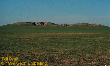
Distant view of Tell Brak. |
| The
current excavations are investigating two periods in the history of the
site: the Uruk Period (ca. 4100-3100 B.C.) when the site grew
to
become one of the first large cities in Mesopotamia; and the mid-third
millennium, when historical documents indicate that the site was an
important
center, but which has been little-known archaeologically.
From 1999 through 2001, the excavators worked with Learning Sites to visualize both of these periods. |
|
|
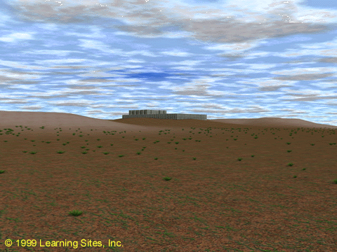
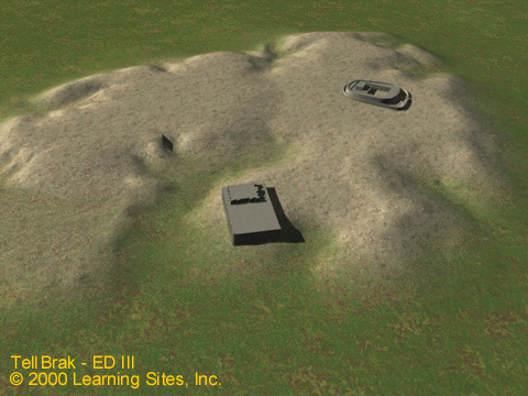
| We were interested in the urban topography of the Uruk Period city, and specifically in the visibility of the Eye Temple across the site and from the surrounding plain. A rendering (at the right) depicts the temple on its platform set on a computer model of the mound as it would have appeared at that time (later layers of the site were stripped away by Learning Sites for their digital terrain model, based on known elevations from the various excavations); it showed how the temple visually dominated the site. |
(click on the image to enlarge) |
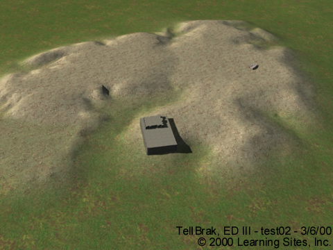
| For the mid-third millennium BCE, in which we are excavating a large public building (located at the right-hand side of the mound in the render immediately to the right), Learning Sites has modeled a possible form for the building that took into account prominent man-made features of the topography of the site (and based on the so-called Temple Oval from Khafaje). The images at the right are taken from the Learning Sites virtual world.
This
process has
been extremely valuable to us in planning further excavation on site,
and
will continue to do so as we explore this complex building further.
|
  (click on an image to enlarge) |
|
| Text above and bibliography supplied by Geoff Emberling.
Emberling,
Geoff
et al. 1999. "Excavations at Tell Brak 1998: Preliminary Report," Iraq 61:1-41. Mallowan, M. E. L. 1947. "Excavations at Brak and Chagar Bazar," Iraq 9(1–2):1–266. Oates, David and Joan Oates. 1994. "Tell Brak: A Stratigraphic Summary, 1976–1993," Iraq 56:167–176.
|
| Reference Information
page created: January 10, 2001 page updated: December 24, 2007 you are here: Learning Sites Home page ==> Learning Sites Index page ==> Til Brak, Syria, Homepage this page's URL is: http://www.learningsites.com/Brak/Tell-Barsib_home.html page author: Learning Sites, Inc. © 2001-2016 Learning Sites, Inc. |